STENUNGSUND STENUNG 3:282
About the property
Fastighet med areal 65,264 m2 och med adressen Västra Köpmansgatan 18, 444 30 Stenungsund. På fastigheten finns 32 st byggnader som består bland annat av flerfamiljshus,småhus med flera lägenheter,friliggande småhus. Det finns åtta komplementbyggnader och fler än tio övriga byggnader och fler än tio byggnader med verksamhet och fem bostäder och en byggnad med samhällsfunktion. Fastigheten består av tre områden.
Report directly from Lantmäteriet
Choose between a basic or complete report for detailed information about purchase price, easements, regulations, rights, registrations and much more.
See our reports →Property location and areas
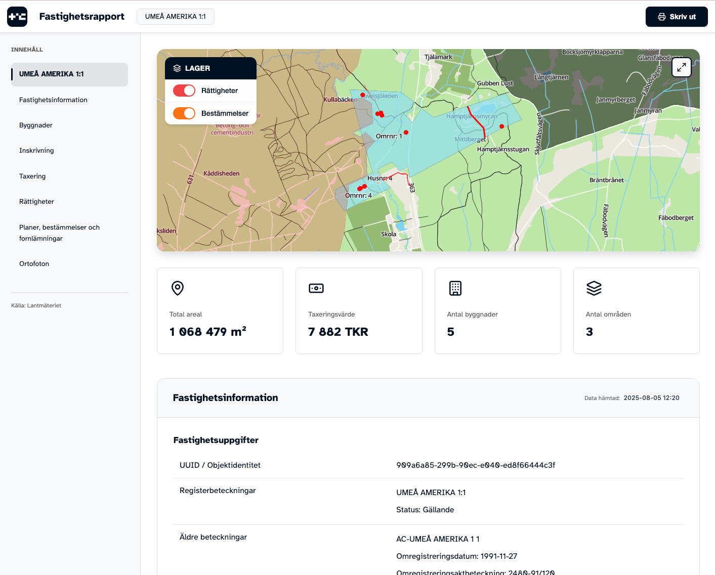
Shown in blue fastighetens plot boundaries and areas where numbering is done according to Lantmäteriet.
Detailed information
Area information
| Total area | 65,264 m² |
| Land area | 65,264 m² |
| Number of areas | 3 pcs |
Buildings
| Number of buildings | 32 pcs |
| Building types | Komplementbyggnad Komplementbyggnad Övrigt byggnad Övrigt byggnad Övrigt byggnad Övrigt byggnad Verksamhet Komplementbyggnad Övrigt byggnad Verksamhet Verksamhet Bostad Övrigt byggnad Komplementbyggnad Verksamhet Bostad Komplementbyggnad Övrigt byggnad Komplementbyggnad Verksamhet Övrigt byggnad Komplementbyggnad Verksamhet Bostad Verksamhet Komplementbyggnad Verksamhet Övrigt byggnad Övrigt byggnad Bostad Verksamhet Verksamhet Övrigt byggnad Verksamhet Bostad Övrigt byggnad Verksamhet Samhällsfunktion |
| Purpose | Flerfamiljshus Flerfamiljshus Flerfamiljshus Småhus med flera lägenheter Friliggande småhus |
Location & Address
| Address |
Västra Köpmansgatan 18 444 30 Stenungsund The property has multiple location addresses |
| Coordinates |
58.0687°N, 11.8185°E
WGS84 |
Choose your report
Get access to detailed property information instantly. Delivered immediately with current data from Lantmäteriet.
Basic general
All the basic information you need.
- Interactive property map with buildings, plans, regulations & ancient monuments
- Areas, buildings & building parts
- Address
- Area
- Rights (e.g. road, jetty, power line)
- Share in joint facilities & common land
- Property legal measures
- Plans, regulations & ancient monuments
- Taxation details (type code, assessed value & partial values)
- High-resolution aerial photos (orthophotos) up to 10 years
General complete
Comprehensive with everything available.
- Everything from General basic, plus:
- Registrations (contractual rights etc.)
- Legal title
- Notes
- Mortgages*
- Owner information*
- Previous owners*
- Property prices (all historical)
- Valuation unit information (living area, year of construction, municipal water & sewage)
- Taxed owner*
See example report
Explore what our property reports contain
Get a complete overview
Click on the image to see a complete example report. The report shows all available information about a property - from maps and boundaries to mortgages and easements.
This example report gives you a complete overview of the information you receive when you order a report for this or any other property.
- Detailed maps and aerial photos
- Property boundaries and area
- Taxation information and valuation
- Mortgages and easements
- Legal title and owner history
- Building information